The Brahmaputra River, a lifeline for millions, flows through China, India, and Bangladesh, connecting diverse communities, cultures, and economies. Originating from the Kailash ranges of the Himalayas at an elevation of 5,300 metres, the river traverses 2,900 kilometres before merging into the Bay of Bengal. As it enters India through Arunachal Pradesh and meanders through Assam, its gradient flattens, resulting in a braided pattern that brings both opportunities and challenges to local communities. With over 20 tributaries from the north and 13 from the south, the Brahmaputra becomes a dynamic force that influences the socio-economic fabric of the northeastern region of India. However, managing its vast resources and mitigating its unpredictable nature requires a robust and sustainable approach—one that the Brahmaputra Board has been diligently pursuing for over 40 years.
Commitment To Sustainability

Operating under the Ministry of Jal Shakti, the Brahmaputra Board, headquartered in Guwahati, is tasked with the integrated management of the Brahmaputra, Barak and other river valleys of the northeastern region. The Board's mission is to foster integrated, equitable, and sustainable development and utilisation of the region's river basins and water resources while addressing the challenges of flood control, bank erosion, and congestion. Through rigorous surveys, investigations, preparation of masterplans and detailed project reports and execution of projects in consultation with all the nine basins states of the region, the Board has been silently and relentlessly developing the potential for irrigation, hydroelectric power, navigation, and tourism to foster economic development of the area.
The Board's strategy incorporates collaborative efforts with state governments and key stakeholders, leveraging cutting-edge technology and domain expertise to achieve integrated flood and river basin management across the northeast region.
Tourism For Progress
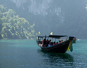
In recent years, the Government of India has identified tourism as a key driver of economic growth in the northeast. With its rich cultural and ecological tapestry, the Brahmaputra is at the heart of this initiative. The River Tourism Project envisions an integrated development approach by identifying and enhancing hotspots along the Brahmaputra's banks. These include iconic sites such as Guwahati, Majuli, Kaziranga National Park, Sualkuchi, Tezpur and Dibrugarh. By focusing on creating state-of-the-art infrastructure for river cruising, water adventure sports, and eco-tourism, the project seeks to boost the region's tourism potential, generate employment, enhance cultural preservation, and contribute to socio-economic development.
Tackling Conflicts And Challenges
Despite its potential, the Brahmaputra's bounty often gives rise to conflicts among different user groups. Farmers depend on the river for irrigation, fishermen rely on its waters for their livelihood, and hydroelectric projects seek to harness its power—all creating competing demands.
The Brahmaputra Board recognises the need for a comprehensive governance framework to address conflicts arising from competing demands on the river's resources. This involves fostering coordination between local communities, governments, and industry players to promote shared understanding, establishing community-based management models that empower local stakeholders. The Brahmaputra Board supports communities, including artisans, to conserve the river's resources and facilitates discussions between communities and policymakers.
Empowering The ‘River People’
The Brahmaputra river islands, locally known as "char-chaporis," are home to nearly 2.5 million people. However, these communities remain vulnerable to displacement due to constant erosion and flooding. Integrating these marginalised communities into the river's management framework is crucial for sustainable development. The Brahmaputra Board is committed to ensuring that these communities are not only beneficiaries but also active participants in conserving and utilising the river's resources.
Key Accomplishments
The Brahmaputra Board has prepared master plans for 52 rivers and tributaries, offering valuable recommendations to state governments and central agencies to address floods, erosion, and congestion while enhancing hydropower, irrigation, navigation, aquaculture, and tourism potential in the northeast. It has developed DPRs for multipurpose projects on Subansiri, Siang, Dibang, Lohit, Barak, and others, with some projects completed and others underway. DPRs for the Simsang and Jiadhal rivers are currently being prepared. Since 2019, the Board has been safeguarding communities across Assam, Meghalaya, Manipur, Arunachal Pradesh, Mizoram, Nagaland, Tripura, Sikkim, and northern West Bengal through anti-erosion, bank protection, and river training projects. In 2002, the Board took over Majuli, the world's largest river island, to protect it from flood and erosion damage. A CWPRS study from Pune confirms that 27.35 sq. km of land was reclaimed in Majuli between 2000 and 2023, showcasing the Board's success. For 20 years, it has been working to restore the Dibang and Lohit rivers, protecting the Dhola Hatiguri area near Dibrugarh, Assam. Additionally, the Board conducts research to enhance its water resource management and project design expertise. Its North-East Hydraulic and Allied Research Institute (NEHARI) focuses on testing, modelling, research, and capacity building.
What's New?
The Brahmaputra Board is rejuvenating spring sheds in Nagaland, Meghalaya, Sikkim, Arunachal Pradesh, and Mizoram to address declining spring water yield and quality due to demographic and industrial pressures. It also supports traditional water management practices, implements bio-engineering techniques for riverbank protection, and prepares GIS-based masterplans for rivers using advanced technology.
 Publish for free


 zpostcode
 Recruit
 weather
 mreligion
 Yellowpages
 sport
sport constellation
 shopping
 name
name game
game directory
 literature
 Word
Word tour
tour furnish
 Lottery
 tftnews
 lyrics
 News
News digital
 car
car dir
dir Edu
Edu Finance


