The Dooars evokes images of smoky blue hills, emerald-green tea plantations, and cotton-like clouds. The Sankosh River divides the Dooars into its western and eastern portions, spread across Sikkim and West Bengal. It serves as Bhutan's entry point into India and is located in the eastern Himalayan foothills. One of the lesser-known tourist destinations in the Dooars is Suntalekhola, situated between 650 and 950 metres above sea level in the Gorubathan CD block. The name of this tranquil spot comes from a small creek called ‘Suntaley Khola’. This region, part of the Kalimpong Range, is characterised by sharply rising hills and numerous small streams.
A Region Rich In Biodiversity
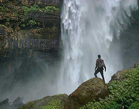
The region is a biodiversity hotspot, boasting numerous tea gardens and wildlife reserves such as Manas National Park, Buxa National Park, and Gorumara National Park. White-water rafting on the Teesta River is available for nature lovers and thrill seekers alike. There are also some fascinating treks and forest safaris to explore. The area is home to a rich variety of bird species, making it a paradise for birdwatchers.

The region is a popular destination for birdwatchers. Bird species commonly found here include pond herons, black eagles, hill partridges, red-vented bulbuls, ashy wood pigeons, blue rock thrushes, scarlet minivets, lesser racket-tailed drongos, rufous sibias, grey treepies, spangled drongos, and common green magpies.
Treks and nature trails are also available. Suntalekhola serves as the starting point for several trekking routes, most of which are located in the nearby Neora Valley National Park. The area's scenic beauty, featuring hills, forests, and lush tea gardens, attracts many visitors.
Drive To Neora Valley National Park
Several trekking routes originate from Suntalekhola, most of which are within the adjacent Neora Valley National Park. The river that flows through the boundaries of Neora National Park gives the park its name. The park's numerous hill streams and torrents support a magnificent variety of plant life, which nourishes the Neora River as it winds through the protected area. This region boasts an incredible diversity of flora, which in turn supports a remarkable population of birds and mammals. Among the flora are tiny wild strawberries, wild white orchids (Kurseong white orchids), and primulas, alongside towering Himalayan yew and hemlock trees, as well as about ten species of rhododendrons recorded in the higher ridges of the park. Over 200 different bird species can be found in the area.
Kangchenjunga serves as a stunning backdrop for the park's exceptional trekking paths. More experienced hikers can trek up to Rechi La, while beginners can embark on the straightforward journey to Alubari, take a break there, and return to the starting point. Alternatively, you can enjoy a jeep safari through the jungle. If you go on a hike, you have a good chance of spotting the striking male satyr tragopan, golden eagles, magpies, and a variety of finches and sunbirds. The area is also home to large mammals, including tigers and leopards. The Asiatic black bear frequently leaves pug marks and scratch marks in the region, although it may be challenging to spot the rare red panda. Regular sightings of the goral and barking deer indicate their presence in the area.
Where To Stay
There are numerous basic accommodation options in the area. The West Bengal Forest Development Corporation (WBFDC) manages several cottages and lodges for tourists. For instance, you can book a stay at the Suntalekhola River Camp, located near Samsing village in Gorubathan Block III of Kalimpong district.
Getting There
Bagdogra is the main airport serving the entire Dooars region. Siliguri, located 12 km east of Bagdogra, acts as the gateway town, from where buses, jeeps, and taxis head towards the hill area. The nearest mainline railhead is New Jalpaiguri, with other accessible rail stations including Siliguri, Alipurduar, and Cooch Behar, from which one can hire a jeep or car to reach the area.
 Publish for free


 zpostcode
 Recruit
 weather
 mreligion
 Yellowpages
 sport
sport constellation
 shopping
 name
name game
game directory
 literature
 Word
Word tour
tour furnish
 Lottery
 tftnews
 lyrics
 News
News digital
 car
car dir
dir Edu
Edu Finance


